Here is the final map of our trip. http://goo.gl/maps/hou7E
I like to look at the Google Map in "Maps" then "Terrain" view. It makes many of the surface features much more obvious....and its really easy to see the Cascades Graben in this view (Western Cascades to the left and Green Ridge to the right).
I like "Satellite" view for looking at lava flows.
----
We...well *I*...had a fantastic time. We couldn't have asked for better weather...no clouds anywhere...even the usually cloud covered peaks.
We headed out Hwy 22 toward Santiam Jct before sunrise. Along the way we stopped to observed the differences in stream characteristics & processes below and above Detroit Dam.

Outcropping bedrock causes the rapids here...North Santiam State Park. Photo by GEM.

Had the "V" versus "U" shaped valley discussion here. MP 59 along the North Santiam River. Photo by GEM.
Both of the above stops had obvious areas of erosion and deposition including cut banks and mid-challel bars...also erosion mitigation at MP59...some features are easy to spot in "Satellite" view on the Google map. Note that there is "Street View" available at the boat ramp at North Santiam State Park.
If one has time there are plenty of great stops along the North Santiam on this segment of the Hwy 22. It's one of my favorite rivers to explore close to Salem.
---
At Santiam Jct we headed to the Hoo Doo ski bowl turn off on Hwy 20.
Big Lake was our destination but we also discussed Mount Washington, Hayrick and Hogg Buttes, and Hoo Doo with respect to volcanic and glacial processes.

Best view from here ever!! Mount Washington from Big Lake. Photo by GEM.

Hayrick Butte from Big Lake. Photo by GEM.

Photo op. Three Fingered Jack from the road out of Hoo Doo ski bowl. Photo by Hols.
----
Next we made two quick stops along Hwy 20 to view and discuss the formation of Blue Lake and Suttle Lake.

Mount Washington and Blue Lake from the Mount Washington viewpoint. Photo by GEM.
Blue Lake is hard to see from the road and we've tried to access it from the Suttle Lake side with no success (private gate). If anyone knows a better place to see/access it please let me know!!

Suttle Lake from with Black Butte in the background. Photo by GEM.
----

View of Mount Jefferson from the Metolius Headwaters viewpoint. Photo by GEM.
Quick stop along Hwy 20 on the way to Hwy 242 to discuss the relationship between Black Butte Swamp, Black Butte, and the Metolius River.

Black Butte Swamp. Photo by GEM.
----
In retrospect I am so glad we added this segment of the trip even though it made for a very long day! The views of the Sisters and other peaks is spectacular along this road on a clear day.
If you are reading this post you are probably getting the picture that this was as near a perfect autumn day in the Cascades as you get!! We saw nothing but sunshine and blue sky!!!
Here we discussed volcanism and lava flows, jointing of rocks, extrusive rocks, and weathering processes.

Mount Washington from the first lava field viewpoint along Hwy 242 coming from the east. Photo by GEM.
I had to laugh at the view of Mount Hood from Dee Wright Observatory...I'd never seen it before from here...and last weekend we were all bummed that it was too cloudy to view...lol. You'll have to zoom way in to see the peak.
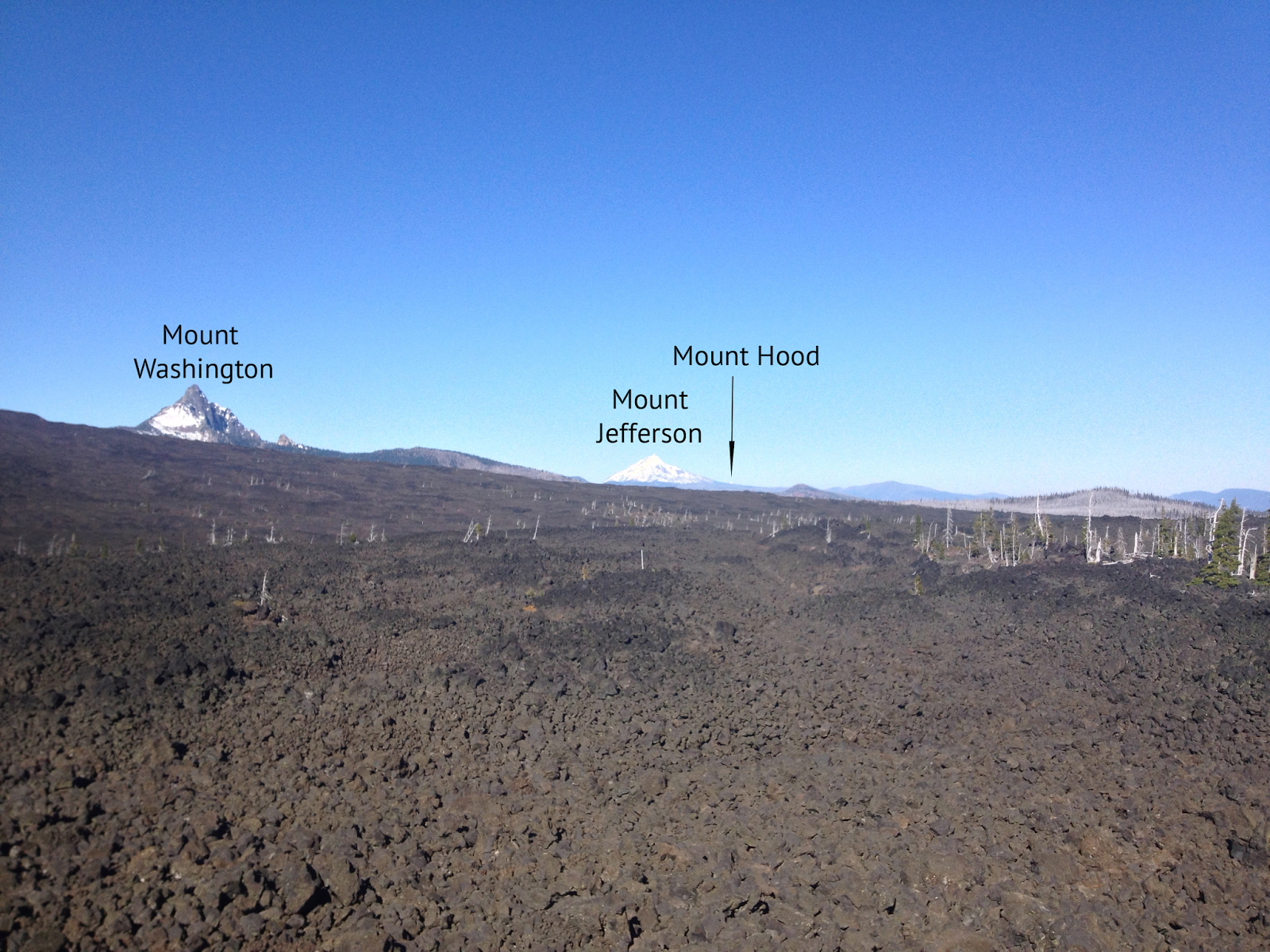
View from Dee Wright Observatory. Photo by GEM.
We were looking into the sun here...it was so bright I was crying under my sunglasses. It was also a very comfortable 60 degree here. Have I mentioned it was absolutely gorgeous?! Note my "Rock Star" shirt. ;)

My students and I at Dee Wright Observatory. Photo by GEM.
We followed the highway west to out next official stop, Proxy Falls...making one unofficial stop (photo op) to look at the Sisters.

North and Middle Sisters. Photo by Hols.
The lighting at Proxy Falls wasn't good for pictures so here is a shot from our last trip with Lockwood in August. Proxy Falls has a fun puzzle that I was fortunate to learn from Anne Jefferson via Lockwood. One of the two students who walked in with me (we arrived first) got the problem and answer right off...I was very proud!

Proxy Falls. Photo by GEM.
We made a brief stop at a spring along hwy then headed to Sahalie Falls. This picture is from our last trip in August.

Natural spring. Photo by GEM.
Sahalie Falls on Hwy 126 was not an official stop since I had the field questions printed before I found out it relationship to Clear Lake. It was well worth stopping for. Lockwood recommended it and it was spectacular!!

Sahalie Falls. Photo by Hols.
Next stop was Fish Lake also on Hwy 126. Here we fully discussed Sand Mountain volcanism and the relationship between Clear Lake and Fish Lake. I prefer Fish Lake to Clear Lake as a field trip stop for ease of access and lack of crowds. Clear Lake has been downright crowded every time I've ever stopped.
At Fish Lake we also observed what a difference a week can make.


Fish Lake with water on 10.13.13...and without water on 10.20.13. Photos by Hols.
Many colors of scoria can be seen here along with great lava bombs (some as much as 1m or more in diameter)...both those that solidified fully in the air and the bread crust type.

Fighting sunlight at Little Nash Crater. Photo by GEM.

Pyroclastic material at Little Nash Crater. Photo by GEM.
From here we called it a day and headed back to Chemeketa...arriving after dark. Thankfully my students were troopers and *seemed* to have a good time.
No comments:
Post a Comment